How Much Does a Thermal Drone Roof Inspection Cost in Houston?
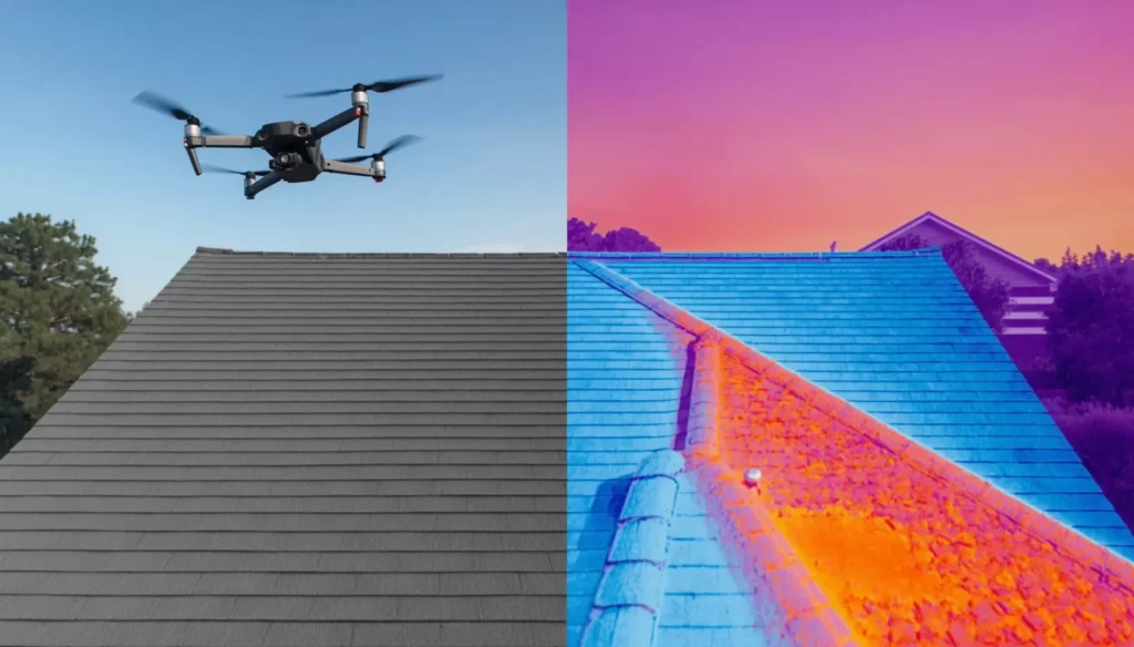
A thermal drone roof inspection in Houston typically costs between $300 and $800. Simple single-family roofs typically start around $300–$500, while larger homes, complex rooflines, and detailed reporting move the price toward $500–$800 or more. The final figure depends on roof size, building height, access, and how much analysis and reporting you need. Hidden moisture, insulation defects, and storm-related concerns are hard to locate without walking on vulnerable roofing materials. A thermal drone roof inspection documents temperature patterns across broad roof areas without direct contact — and a property-specific quote from ISKY Drone Services can define the imagery, coverage, flight conditions, and report before work begins. Request a Thermal Roof Inspection Quote → Get Clear Thermal Roof Pricing Before You Book A thermal drone roof inspection is a non-contact assessment that combines aerial photography with infrared data to identify areas that may require closer investigation. It can help reveal patterns associated with wet insulation, thermal bridging, or inconsistent heat transfer — but the images must be interpreted in the context of weather and roof construction. Our thermal drone imaging services are built around that interpretation step, not just the raw scan. Many straightforward residential roof inspections in Houston start at approximately $300 to $500. Larger homes, complex rooflines, multiple buildings, or more detailed analysis commonly raise the price toward $500 to $800 or more. Properties elsewhere in Harris County may also incur travel or scheduling considerations depending on their location and flight requirements. A written quote should explain whether the price includes thermal capture, visual photographs, analysis, annotated findings, and a formal report. The lowest advertised price may cover only a brief flight or a limited number of images. Compare the complete scope, because collecting thermal data without interpreting or mapping it provides limited decision-making value. A custom proposal is generally more reliable for commercial buildings, multifamily communities, and estates with detached structures. It establishes the number of buildings, expected roof coverage, deliverables, and weather window before the operator arrives. Houston Property Owners Need Answers Without Roof Access Risks Houston’s Gulf Coast climate exposes roofing systems to intense solar heating, heavy rain, hail, wind, and high humidity. These conditions can create storm damage or moisture concerns that stay concealed beneath an apparently intact roof surface. Standard aerial photography records visible roof material conditions but cannot display heat patterns. Thermal imaging adds another layer by showing temperature differences that may correspond with retained moisture, uneven insulation, or air movement around vulnerable assemblies. Roof penetrations deserve particular attention because vents, skylights, plumbing stacks, exhaust systems, and HVAC curbs interrupt the continuous roofing membrane. Temperature anomalies near these features can help direct a roofer toward specific areas instead of requiring an unfocused search across the entire structure. A drone roof inspection is especially practical for steep, fragile, high, or expansive roofs that are difficult to examine on foot. Keeping personnel off questionable surfaces reduces exposure to falls and helps avoid additional damage to brittle shingles, tiles, coatings, or membranes. For roofs where surface condition is the main concern, our aerial drone inspection services can capture high-resolution detail with or without a thermal pass. A post-storm flight can document visible displacement, debris, punctures, ponding, and flashing concerns before conditions change. However, aerial documentation does not determine insurance coverage or prove that every anomaly resulted from a particular weather event. Property owners gain the most value when they use drone findings to prioritize targeted physical evaluation. The approach narrows the search area while leaving definitive diagnosis and repair recommendations to qualified roofing or building professionals. What a Thermal Drone Roof Inspection Includes A complete inspection should combine high-resolution visual aerial imagery with radiometric thermal imagery when environmental conditions support reliable data collection. Radiometric files preserve temperature information for individual pixels, giving the analyst more information than a simple colorized infrared photograph. The scope should specify roof-area coverage, image files, annotated images, turnaround time, and the format of the roof inspection report. Clear deliverables prevent confusion about whether the purchase includes raw imagery, interpreted findings, or both. Thermal roof leak detection does not directly show water passing through a roof. It identifies a temperature anomaly that may be associated with moisture retention, insulation variation, roof composition, shade, mechanical equipment, or another source requiring verification. Visual Aerial Roof Documentation Visual images can document damaged or displaced shingles, open seams, flashing concerns, debris, roof penetrations, and ponding water. These photographs create a dated condition record that homeowners, property managers, roofers, and other authorized parties can review without relying solely on written descriptions. The same high-resolution capture used for our drone photography and videography work applies here. Aerial files may also support insurance documentation, maintenance planning, or contractor discussions. They do not guarantee claim approval, establish causation, or replace documentation requested by an insurer. Infrared Findings and Reporting Infrared thermography compares emitted thermal energy across the roof surface under suitable conditions. Unusual patterns may indicate areas worth examining for trapped moisture, insulation gaps, air leakage, or differences in roof materials. The report should map each notable image to its roof location, describe relevant limitations, and recommend proportionate next steps. Responsible reporting distinguishes an observed thermal pattern from a confirmed defect, which helps prevent unnecessary repairs based on infrared data alone. What Changes the Price of Your Inspection Roof size is only one pricing variable, because flight time does not represent the entire workload. The number of structures, roof pitch, building height, material type, penetrations, roof sections, and requested image detail all affect capture and analysis time. A thermal survey normally costs more than a visual-only drone inspection. Infrared equipment, weather-dependent scheduling, radiometric analysis, image annotation, and reporting add technical requirements beyond basic photography. Travel distance, controlled airspace, rush deadlines, restricted access, safety coordination, and site-specific operating rules can also alter the quote. A commercial roof inspection may require contact with facility managers, designated launch areas, tenant coordination, or work outside busy operating periods. Typical Houston Pricing Ranges The following figures are planning ranges rather than fixed prices: Property type Typical range Notes Small, straightforward residential roof $300 – $500