Droneshouston

commercial drone services

Commercial drone inspection of an industrial facility and surrounding property from above
Blog

When a Commercial Building Needs a Drone Inspection in Houston

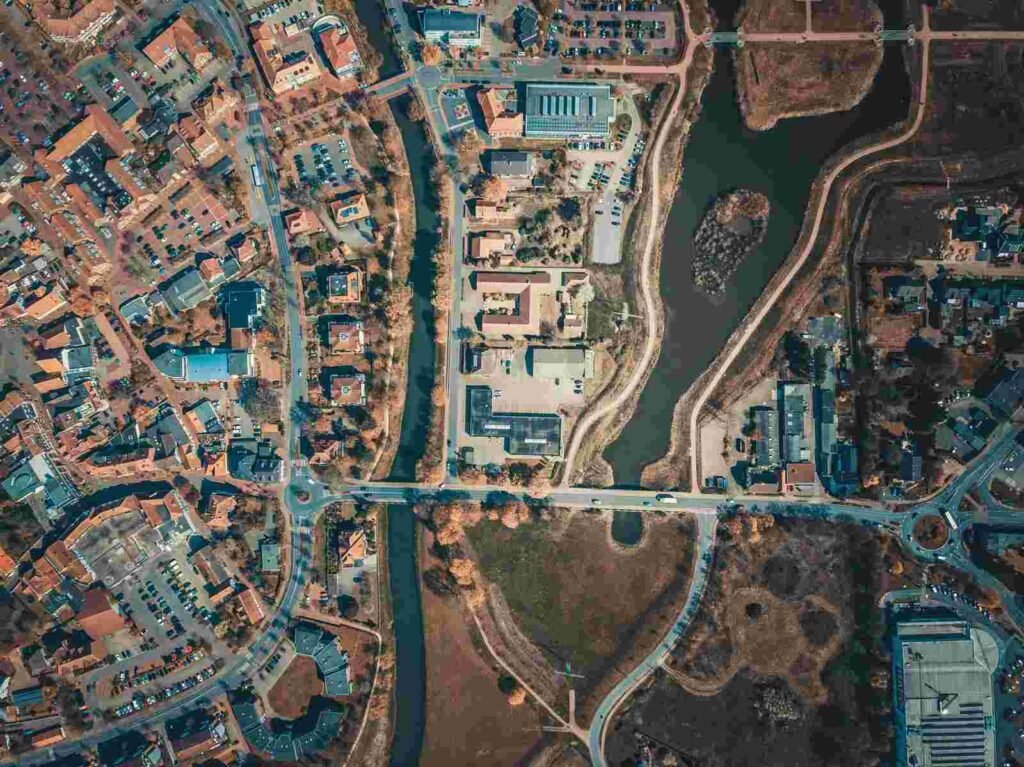
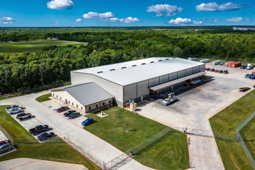
Roof failures often start as small exterior defects, not dramatic leaks, and that is why many commercial owners miss the cheapest repair window. For anyone evaluating When Does a Commercial Building Need a Drone Inspection? The practical answer usually comes down to whether the building needs safer access, faster documentation, or clearer evidence than ground-level observation can provide. In Houston, that question matters more because heat, humidity, storm exposure, and large low-slope roofs accelerate hidden wear. This guide explains the clearest triggers, what drone inspections actually capture, and where aerial evidence fits into maintenance, insurance, and capital planning. How To Tell If a Drone Inspection Is the Right Next Step A drone roof inspection is a remote exterior review that uses aerial imagery, video, and time-stamped photos. It documents roofs, facades, and site features without sending people onto every surface. The real value is systematic data collection. A commercial drone inspection creates a repeatable record instead of relying on a few snapshots taken from a ladder. A drone is usually the right next step when access is risky, slow, disruptive, or incomplete from the ground. Commercial teams benefit from broader roof visibility and safer review of elevated walls. They also gain documentation that can be compared over time. This helps track blistering, movement, and moisture-related changes. The selection process is straightforward. Use drones when safety improves, coverage expands, documentation quality matters, or speed is important. Repeatable records also support better long-term planning. In practice, a commercial drone inspection is especially useful for large roofs, multi-tenant properties, active facilities, and buildings where traditional access could interrupt operations before a problem is confirmed. What a Drone Inspection Can (and Cannot) Do A drone inspection can capture high-resolution views of hard-to-reach areas and produce annotated imagery that supports maintenance planning, insurance files, and contractor scoping. It is a strong first-pass tool because it is non-destructive testing in the practical sense of observing conditions without cutting into assemblies or adding roof traffic. A drone inspection cannot replace every hands-on method. Weather limitations, airspace constraints, and line-of-sight rules can affect scheduling, and some conditions still require physical verification, moisture testing, or close contact with details such as flashing terminations, drains, and downspouts. Houston-Specific Reasons Drone Inspections Matter More Houston buildings face a harsher exterior maintenance cycle than properties in milder climates. Hurricane exposure, tropical storms, hail, high UV levels, and humidity all accelerate exterior deterioration. As a result, damage often develops in multiple areas. A commercial drone inspection can reveal ponding water, clogged roof drains, and membrane stress before tenants report leaks. Flat and low-slope roofs are common across Houston commercial properties. Unfortunately, drainage failures are often difficult to identify from the ground. A drone can detect standing water patterns, blocked outlets, and surface wear without repeated ladder setups. This approach reduces roof traffic and minimizes disruption to building operations. Business continuity is another advantage of a commercial drone inspection. In occupied offices, retail centers, warehouses, and industrial facilities, less lift staging and manual access means less interference with parking, loading zones, and tenant circulation. Local Areas Where Access Challenges Are Common In Downtown Houston, Midtown Houston, and Uptown corridors near The Galleria, exterior access can be constrained by traffic, limited staging space, and pedestrian activity. Close-up capture from a drone helps teams inspect parapets, facade joints, and rooftop edges without turning a simple review into a lift logistics project. Large-footprint properties in the Energy Corridor, Westchase, and the Port of Houston area benefit for a different reason: scale. Aerial coverage is efficient on warehouses, campuses, and industrial buildings where walking every roof section can consume hours before anyone identifies the highest-risk zones. Trigger #1: After Major Weather Events and Suspected Damage After a storm, a drone inspection is often the fastest way to determine whether visible calm is hiding real storm damage. Wind uplift, hail damage, debris strikes, displaced HVAC equipment, and loosened curb flashing can all occur without producing immediate interior symptoms. Ground-level observation is not enough after severe weather because small failures often become leaks days or weeks later. That delay matters operationally because early documentation can reduce business disruption, support repair prioritization, and preserve evidence before temporary patches alter the original condition. The best timing is as soon as the site is safe and access conditions are stable. If possible, capture the roof before temporary repairs change the damage pattern, since early imagery often becomes the clearest record of causation. What to Look For in the Aerial Findings The most important roof findings include seam separation, blisters, punctures, edge lift, exposed substrate, and stress around penetrations. Those details matter because membrane failure often starts at transitions, not in the middle of an open field. Drainage issues deserve equal attention, especially after Houston rain events. Look for ponding, clogged scuppers, blocked gutters, overflow paths at downspouts, and water collecting near parapets, since those patterns often explain later leaks in retail and office properties near dense districts such as The Galleria. Trigger #2: Preventive Maintenance Before Problems Appear The most cost-effective drone inspections often occur before problems become urgent. Baseline aerial documentation creates a visual record of the property. It helps facility teams identify cracking, movement, drainage changes, and surface wear over time. A commercial drone inspection makes it easier to compare conditions across multiple inspection cycles. Historical comparisons turn a drone into a valuable maintenance tool. Small membrane splits, early facade cracks, and minor drainage issues are usually less expensive to repair when found early. Delayed action can lead to interior damage, emergency repairs, and a shorter roof lifespan. A practical inspection schedule depends on the property. Many newer buildings benefit from annual inspections. Older roofs, storm-exposed sites, and properties with recurring drainage concerns may benefit from semiannual reviews. Post-storm inspections can then supplement the baseline documentation rather than replace it. Systems Commonly Checked During Preventive Flights Preventive flights commonly review rooftop units, HVAC curbs, exposed penetrations, loose panels, and visible condenser damage. Rooftop mechanical zones fail faster than open roof

Construction drone mapping aerial view of a commercial development site
Blog

Drone Mapping Services for Construction Projects in Houston

Houston projects move fast, sprawl wide, and require project teams to make decisions without every stakeholder on-site.Construction drone mapping gives project teams a reliable way to track activity, verify progress, and share current site conditions with owners, lenders, and contractors. Drone mapping services in Houston close the visibility gap. Teams use current aerial data during meetings, pay applications, and claims reviews to make more informed decisions. Weather is a major factor in Houston construction. Heavy rain, sudden wind shifts, and post-storm cleanup can delay schedules. Timestamped aerial documentation helps teams verify site conditions and support project records. Owners and lenders want confidence without extra site visits. Subcontractors need clear information about access routes, laydown yards, and sequencing. This becomes even more important when crews rotate between multiple projects due to labor shortages. What Drone Mapping Services in Houston Actually Deliver Drone mapping is more than aerial photos. The value comes from a repeatable process that captures the same coverage the same way over time, so teams can see what changed, when it changed, and what it affects. A proper mapping program shows installed work, staged materials, and blocked areas. It also creates a defensible audit trail for change orders, delays, and scope disputes. Most Houston construction teams use a mix of visual documentation and measurable mapping outputs. The choice depends on whether the question is “what happened?” or “how much changed?” Baseline deliverables typically include nadir imagery, oblique imagery, site walkthrough video, and panoramas from key vantage points. Teams that need measurements can use photogrammetry outputs such as orthomosaics, 3D models, point clouds, and DSM or DTM surfaces for grading and drainage analysis. Progress Mapping Weekly or biweekly aerial mapping creates a consistent record for construction progress monitoring, owner reporting, and lender visibility.. Our drone mapping services are built around repeatable capture standards. Each flight produces data that teams can compare directly with previous collections. When the same views repeat every week, side-by-side comparisons become obvious and the conversation shifts from opinions to evidence. Annotated maps are among the most-used deliverables. Pin-based issue tracking ties field notes to specific locations, then feeds into progress reports that owners and project managers can review without a site visit. Orthomosaic and 3D Deliverables High-resolution orthomosaics support plan overlays, layout verification, and clearer communication than unstructured photo folders. Teams can use georeferenced orthomosaics immediately in CAD, BIM, and GIS platform A 3D model, point cloud, and digital surface model help teams evaluate grading, structure context, and changing site geometry over time. These outputs also support stockpile measurements, earthwork calculations, and site logistics tracking so teams can monitor haul routes, crane pads, and material staging more accurately. For roof and facade reviews, our aerial inspection services and thermal imaging services extend the same workflow into hard-to-access areas with less field exposure than manual checks. Common Construction Uses for Drone Mapping Drone mapping supports many construction activities beyond simple progress photos. Houston contractors use aerial mapping for earthwork tracking, stockpile measurements, site logistics planning, and pre-construction documentation. Teams also use mapping for lender draw inspections, change orders, subcontractor coordination, and post-storm assessments. Current site data helps project teams identify issues earlier. It also improves stakeholder communication and supports better decision-making. As projects grow more complex, regular aerial mapping creates a centralized visual record. Owners, contractors, and consultants can use that record to stay aligned throughout the construction process. When You Need Mapping vs. Visual Documentation Use mapping when the question is quantifiable. If you need quantities, distances, grading progress, or overlay analysis against design, an orthomosaic, point cloud, or 3D model is the right tool. Use visual documentation when the question is communicative. Progress photos, walkthrough videos, and annotated snapshots help owners, stakeholders, and lenders understand current site conditions. Teams typically use these deliverables to improve visibility rather than perform precise measurements. Many projects use both. The cadence and deliverable mix should match how fast the site changes and what decisions are coming up in the next two weeks. Houston Airspace and Flight Planning Sites near George Bush Intercontinental Airport, William P. Hobby Airport, and the Houston Ship Channel often require LAANC authorization that shapes the entire collection schedule. Crane picks, concrete pours, and active traffic control also affect when a safe and complete flight is possible. Local planning matters before launch, not after. All ISKY operations are conducted by FAA Part 107 certified pilots who handle airspace coordination, site safety planning, and geofencing before every mission. Getting Started with Drone Mapping in Houston The most useful mapping cadence is usually regular, not reactive. Consistent flights build a site record that supports pay applications, inspection reviews, and post-weather recovery documentation in ways that one-off flights cannot. If your team needs clearer progress records, better quantity visibility, or more reliable site documentation, request a project review . Learn more about our services: Drone Mapping Â· Aerial Inspections Â· Thermal Imaging Â· Photography & Videography

drone roof inspections Houston commercial warehouse
Blog

Why Houston Businesses Are Switching to Drone Roof Inspections

Faster Roof Answers Without Ladders, Lifts, or Disruption Drone roof inspections give Houston businesses a fast, clear roof inspection without ladder use, lift rental, or a long manual walkthrough. Drones Houston captures high-resolution imagery and can add thermal scanning to support leak detection when conditions allow. Schedule a Drone Roof Inspection Best-Fit Roof Types in the Houston Area Some roofs are slow, risky, or expensive to inspect with a roof walk, especially when access is limited. Drone technology makes hard-to-reach roofs easier to document without stepping on fragile areas. Proof You Can Share With Stakeholders in Minutes ★ Rating and review count available on request | Years serving Houston available on request You get stakeholder-ready deliverables: clear photos, labeled findings, and time-stamped documentation that holds up in meetings and email threads. Use the same inspection report package for maintenance planning, insurance claims conversations, and contractor scope validation. The organized file structure also improves data accuracy when multiple roofing contractors, insurance representatives, and property managers review the same roof condition documentation. Built for Commercial Decision-Making One inspection package reduces back-and-forth between tenants, facilities, ownership, and contractors. Visual evidence supports budget approvals with fewer assumptions and fewer repeat visits. As construction trends continue pushing more commercial development across Houston, property owners are looking for faster ways to monitor roof condition without disrupting active sites or tenants. Common Roof Inspection Headaches We Eliminate As construction trends continue pushing more commercial development across Houston, property owners are looking for faster ways to monitor roof condition without disrupting active sites or tenants. Houston Conditions That Increase Roof Risk Houston weather creates fast-moving roof problems that do not wait for a convenient schedule. Heat, humidity, and storms raise the odds of membrane wear, flashing failures, and moisture intrusion. Houston weather can rapidly expose weak seams, damaged flashing, and vulnerable roof penetrations that may not be visible from the ground. What Drones Houston Delivers With Drone Roof Inspections Drones Houston provides drone roof inspections to capture roof condition quickly, with documentation you can use. You get high-resolution imagery, optional infrared imaging, and outputs designed for action instead of guesswork. For related capture needs beyond roofs, see our team’s commercial drone photo and video services. If your site needs more than a roof check, our inspection services for buildings and infrastructure can cover additional exterior assets. For large properties that need measurements and site context, ask about mapping and measured deliverables for planning. Service Options (Use as Cards) Why Businesses Prefer Drones Over Traditional Roof Walks Better Data for Insurance and Maintenance Time-stamped visuals support claim narratives and help align repair scope with what is actually visible. Detailed aerial imagery creates stronger proof of condition before repairs begin, helping roofing contractors and ownership groups compare changes more confidently over time. A baseline roof condition makes change over time tracking easier after storms, repairs, or seasonal wear. For storm timing and local risk context, the National Weather Service Houston/Galveston office is a reliable reference. How the Inspection Works (Simple and Predictable) What We Need From You For active developments or recently completed projects, understanding the jobsite data environment helps improve flight planning, safety coordination, and documentation accuracy. Trust Signals That Matter for Commercial Roof Work You need a vendor that fits commercial schedules, safety requirements, and documentation standards for drone roof inspections in Houston. In addition, Drones Houston focuses on efficiency, accuracy, and documentation-first deliverables for Houston businesses that need reliable roof condition reporting. Compliance and Operational Fit Objections We Hear (and Straight Answers) When a Drone Inspection Is the Wrong Fit Traditional home inspections during a new home purchase may still require in-person evaluations inside attics, insulation systems, and structural components that drones alone cannot fully assess. Book Your Inspection Before the Next Storm Window Closes Post-storm backlogs and insurer timelines make fast roof documentation valuable, especially when multiple sites need the same proof standard for drone roof inspections in Houston. As a result, requesting availability early helps businesses receive a clear inspection plan based on roof type, access limits, and operational goals. In addition, fast documentation becomes even more important after severe Houston weather events when roofing contractors and insurance teams are handling multiple properties at once. Ideal Times to Schedule Frequently Asked Questions About Drone Roof Inspections How do drone roof inspections improve data accuracy? Drone roof inspections improve data accuracy by capturing high-resolution aerial imagery from multiple angles that are difficult to document during a traditional roof walk. This allows property owners, facility managers, and roofing contractors to review consistent visual evidence without relying only on handwritten notes or limited ground-level photos. Can drone inspections provide proof of condition for insurance claims? Yes. Drone inspections create time-stamped photos and video that help establish proof of condition before or after storms, repairs, or maintenance work. Many Houston businesses use this documentation when discussing roof damage, claim timelines, and repair scope with insurance carriers and roofing contractors. Why are roof penetrations important during a roof inspection? Roof penetrations are common problem areas because vents, HVAC units, skylights, drains, and mechanical equipment can create openings where moisture intrusion begins. Drone inspections allow inspectors to safely capture detailed imagery around roof penetrations without stepping across fragile or difficult-to-access areas. How does Houston weather affect commercial roofs? Houston weather creates constant stress on commercial roofing systems due to heat, humidity, heavy rain, hail, and strong wind events. Over time, these conditions can accelerate membrane wear, flashing failure, standing water issues, and hidden moisture problems that may not be visible from the ground. Do roofing contractors use drone inspections before repairs? Many roofing contractors now use drone inspections before starting repair or replacement work because aerial documentation helps validate roof condition, identify damaged sections, and create a clearer scope of work. This can reduce misunderstandings and improve communication between contractors, ownership groups, and insurance representatives. Are drone roof inspections safer than traditional roof walks? In many situations, yes. Drone inspections reduce the need for ladder climbs, lifts, and extended roof walks on steep or

Scroll to Top